Waypoints from Landels-Hill Big Creek Reserve hike Nov. 21, 2005
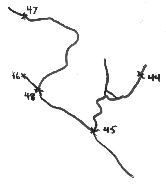
To get to trails, drive past Highlands Camp about a mile, looking for stump on left side of road. Trail starts on cleared dirt road heading NW from where black line starts in the lower right corner of the rough route map above, traced from the screen display of the Garmin GPS mapping software. Watch for flags hanging from high branches on the side trail at 45 toward Canogas Falls. We went only to 44 to see the Santa Lucia Firs. Canyon trail (not sure of the actual trail name) starts at the end of the road at 48. See also here for an early summer hike on the same trail. The highest look-out point of the trail is about at 47. The weather station at 46 is called Highlands Peak and will soon be replaced by an upgraded station.
| 044_lookout_for_Sta_Lucia_firs | 21-NOV-05 1:22:46PM | N36 03.955 W121 33.253 | 2091 ft |
| 045_turn-off_to_Canogas_Falls | 21-NOV-05 1:47:41PM | N36 03.796 W121 33.424 | 2228 ft |
| 046_highest_weather_station | 21-NOV-05 1:58:22PM | N36 03.962 W121 33.674 | 2416 ft |
| 047_serpentine_pine_grove | 21-NOV-05 2:33:13PM | N36 04.140 W121 33.669 | 2404 ft |
| 048_turn-off_to_canyon_trail | 21-NOV-05 3:07:46PM | N36 03.922 W121 33.628 | 2416 ft |
Return to SCERP Fieldtrip to Big Creek Nov. '05 or Bio 317 Field Marine Biology Home Page
Image by D. J. Eernisse © 2005
Web page created using WebMate HyperCard stack by D. J. Eernisse © 2005 on 11/27/05