Current Location: Home > People > Faculty > Joel Weintraub > Ornithology > Local Birding Localities
![]()
Current Location: Home
> People
> Faculty
> Joel Weintraub > Ornithology
> Local Birding Localities
By Joel Weintraub & Bob Allen
Yes, we would like to include maps, but we've got to start somewhere. Please be patient...
[ A | B | C | D | E | F | G | H | I | J | K | L | M | N | O | P | Q | R | S | T | U | V | W | X | Y | Z | Passes & Permits! ]
Everybody on this list should own a copy of :
If you have any changes to the directions presented below, please let me know so I can update the information so we can use it in future reports.
Orange County Rare Bird Alert, (949) 487-6869. Co-compilers: jweintraub@fullerton.edu and Delores Jenisch djenisch@home.com.
|
|
|
To reach the Golden Plover site, take PCH north across the Anaheim Bay Bridge. Turn on the road just past the bridge that
enters the Naval Station. There's a gate across it. Park off to the side and scan the mudflats to the north.
|
|
|
You have some options to see the Booby. You can drive to the end of the Balboa Peninsular and get on the jetty to view the buoy but the strenous hike may take over 15 minutes and some birders have turned back due to difficult conditions. A scope is necessary. You could with 50X view the buoy from the base of the jetty before you decide to walk out.. HOWEVER the bird may not be sitting on top of the buoy but on some supports on its side out of view of the jetties. The Corona del Mar overlook with a 50X scope is much easier although farther away, and is reached by taking PCH to Marguerite and going toward the ocean, turn left at Ocean Street to Inspiration Point Park to scope the buoy... look on the top and the outer left quarter (to you) of the buoy which may be visible as the buoy slightly rotates... to view one roosting area for the bird...look half way up the buoy. One sighting last week of the Booby was on a group of rocks that are just offshore from the northern lookout on Ocean Street where the bird was sitting with pelicans and cormorants.
Take Beach Blvd. south from the 405 freeway. Just before Adams, Newland Center is on the left. Turn into the center. Park directly
behind Mother's Kitchen. From there, follow the trail which goes to the eucalyptus trees and the overlook.
From PCH make a right at Marguerite and then a right at Bayside.
Dan Lockshaw recommends: from Interstate 5 get off at Ortega Hwy (74) in San Juan Capistrano and go east for 21.4 miles to Long Canyon road (the sign also says Los Pinos camp and McConville). Turn left. At the 23.1 mile mark there is a short road/driveway going to the left and pines with Golden-crowned Kinglets. About 50 yards further the road forks, follow the road to the right. Blue Jay campground is on the left at mile 24.0 and at mile 24.4 just past the closed Falcon campground before the road turns sharply to the right is the pullout with the double left arrows, behind which the silky hangs out in the oak tree with the mistletoe. Also look for Townsend's Solitaire and a reported Pygmy Nuthatch.
John LeVine recommends, if nearer to you, taking I-15 to Hwy 74 exit just north of Lake Elsinore. You could continue to the right turn at Long Canyon Road or about 8-9 miles from the Freeway exit take a right to the Blue Jay Campground Road just before El Cariso village. This first right turn is about 8-9 miles from the freeway exit. At 4.0 miles on this Blue Jay road be careful for the LARGE POTHOLE. At 4.5 miles on this road is the silky's oak tree on the right as the road turns sharply to the left.
On Pacific Coast Highway between Goldenwest and Warner.
Reached by taking Palm Avenue off of Goldenwest. Follow it to the end where it intersects with Sea Pointe. Continue on Sea Pointe for about a half a mile until you see a drainage area on the left bordered by dirt roads. Either dirt road can be followed down towards the marsh below.
From MacArthur Blvd., turn east on University and then turn on La Veda. Circle the park to the main parking lot on the east side of the park. The creek and riparian area are nearby.
Adjacent to San Miguel, near the intersection of MacArthur Blvd and San Miguel.
Actually a large reservoir paralleling the Santa Ana River can be reached by getting off of Lincoln Avenue off the Orange Freeway and going east. Make a right on Rio Vista. Turn left on South Street to its end to walk out onto the levee or stay on Rio Vista to its end to scan across the water.
|
|
|
Take Victoria Blvd. from Newport Blvd. and go west. Turn left on Canyon Drive to its end. Park on the street. Take the path that goes down into the park on the left side of the entrance booth to the condominiums.
Take Newport Blvd. to 19th Street and turn west. Make a right on Monrovia. Turn left on Arbor, which goes to a parking lot for the south park side. Cross the bridge over the wash and follow the path alongside the wash.
The LAUGHING GULL was last reported on 22 September 1999. It's usually south of the Hamilton Street bridge over the Santa Ana River. The area is accessed from the parking lot of the Carl's jr. which is just south of the southeast corner of Brookhurst and Hamilton.
On Lambert Road, east of the 57 Freeway.
Carr Park is at the intersection of Heil and Springdale.
West of the 57 freeway, off of Imperial Highway, on State College Blvd. just south of Imperial Highway.
|
|
|
On Dana Point Harbor Drive off of PCH. To avoid paying the entrance fee, instead of turning into the park, turn right and go up to Lantern Bay County Park. Park there and walk down to Doheny.
|
|
|
Bordering Lincoln Ave and Tustin, near the 55 freeway.
On Spring Street, just west of the 605 freeway.
Located adjacent to the Newport Harbor High School on 16th. Go on 16th past the athletic field and look for the sign
|
|
|
Between Adams and Victoria along the Santa Ana River.
Take the 57 Freeway to Yorba Linda and go west. Turn left at the first light after the overpass. The arboretum is to the left.
|
|
|
North of Las Brisas Restaurant on Cliff Drive off of PCH. To avoid parking meters, park on the other side of PCH.
On Goldenwest between Slater and Talbert. The Jack Green Nature area is on the east side of Goldenwest, north of the Park Bench Cafe. The Shipley Nature Center is on the west side, across from the Park Bench Cafe. The west side is reached by walking across Goldenwest, or take Slater west to Edwards and turn south. At Varsity/Central Park Drive, turn left and continue to the parking lot at the end.
|
|
|
At the end of Jamboree, just past the intersection of Chapman Ave and Jamboree. Take Chapman from the 55 or take Jamboree from the 5 or 405.
|
|
|
|
|
|
|
|
|
At Lakeview and Euclid, north of Rosecrans.
Just off of La Paz Road, between Crown Valley Parkway and Aliso Creek Road. Laguna Niguel Regional Park, last reported to us on the 2nd. In the early am it feeds actively, sometimes staying submerged for a long time (grebe style). There is a way to park off of La Paz at Yosemite Street and walk under La Paz Road into the park.
Go south on Brookhurst from Adams. Turn left on Hercules. Turn left on Suburbia and then turn right on Cynthia to its end.
From the 57 Freeway, take Yorba Linda Blvd east. Go past Rose Drive to Jefferson Street. Turn right on Jefferson and then turn left on Carlsbad which will take you to the park.
|
|
|
On University Drive between Culver and Harvard.
On Warner between Brookhurst and Euclid.
|
|
|
|
|
|
From the 91 freeway, take Imperial Highway south to Nohl Ranch Road, turn left and continue past the golf course to Walnut Canyon Road. Turn left there, to end.
Take Seal Beach Blvd. north from the 405 freeway. Turn right on Bradbury Road. Turn right again on Pine. Turn left on Kempton Drive to the park.
|
|
|
Between Irvine Park and the Tustin Ranch area off of Jamboree Blvd. Take Jamboree south from Chapman Ave. and turn west on Canyon View. The park is immediately on the left.
About 1 mile north of Lincoln Avenue on Sunkist.
|
|
|
|
|
|
Apparently there is some discussion about the precise location of Rabbit Island.
Take Oso Parkway east from the 5 freeway. About twenty feet before Oso Parkway dead-ends, turn right onto a gravel road which is labeled as the park entrance.
|
|
|
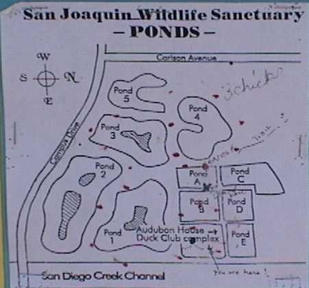
From the 405 Freeway, take Jamboree to Michelson and turn left. Turn right at the second right, Riparian View. Follow signs to the Audubon Headquarters. Trail map.
Take Katella east from the 55 freeway. It eventually becomes Santiago Canyon Road. Turn left at the park sign at Windes Road. Follow winding road to end.
At the end of Main Street, which is reached from Pacific Coast Highway.
Sadly, the Sod Farm is gone and will likely be developed. Please erase it from your list of localities to visit.
Reached by taking Edinger west all the way to the end near the boat launching area. Park in the parking lot and walk across the boat launching area to the edge of Anaheim Bay.
|
|
|
Take Newport Blvd. south to 19th Street and turn right. Go to the end and turn right on Balboa. Take the main dirt path down the hill and then the narrow foot trail which is perpendicular to Balboa.
Not mentioned in last week's summary was the Bendire's Thrasher since no one had called it in. Sandy Koons of Redlands called today to say that it was seen on the 28th. Directions for the Bendire's Thrasher. Park by Le Bard Park in Huntington Beach which is off of Brookhurst and Crailet Drive. Walk to the river and take the bike trail bridge over it...then go north on the bike trail...look for ROCK WRENS along the rocks. You will see a bridge over the accessory flood control channel.... you must do some climbing down to the path that leads to that bridge however.... go through the wire fence near the start of the mesh fence on the lower level....then cross the bridge, go along the road, and make a right turn and head for the brownish dumpster. First to your left is a large island of vegetation, then to the left of the dumpster and to its south are two smaller clumps of brush and trees. The Thrasher is in the second and third clumps. There is a short raptor pole also in the area. Do NOT expect to see the Thrasher in the short bushes. Instead, concentrate on the larger trees, especially the elderberry on the edges of the islands. The bird pops up in those shrubs, then dives into the lower stuff, and then may reappear in the far side of the same island.
Across from the Orange County Fairgrounds on Arlington Drive, between Newport Blvd. and Fairview.
On Kramer Blvd., about 1/2 mile north of Yorba Linda Blvd.
Take Santiago Canyon Road to Modjeska Canyon, almost to its end, and park in Sanctuary Parking lot. See also http://biology.fullerton.edu/tucker/.
From the 405 freeway, take Culver to Campus. Turn left on Campus and follow it to the end. Turn right on Turtle Rock Drive and continue until Turtle Rock Community Park appears on the right.
|
|
|
At University and Campus. Aldrich Park is in the center of UCI Upper Newport Bay (University side) take Irvine Avenue south from Bristol. Turn left at University and park near the end. Follow the path down to the bay. Once you reach the end of the boardwalk and adjoining fence, you are in the right area. Best viewing is from the top of the fence at high tide. Remember, everyone needs to respect the habitat and stay out of the sensitive vegetation.
|
|
|
|
|
|
Located north of the 405 freeway on Beach Blvd. between Hazard and Bolsa.
From the 5 Freeway, take Lake Forest Road inland (north) to Portola Parkway.
|
|
|
|
|
|
On La Palma, east of Imperial Highway.
|
|
|
Revised 5 November 1999.